- Author Matthew Elmers [email protected].
- Public 2023-12-16 21:49.
- Last modified 2025-01-24 09:17.
When reading victorious reports about our achievements in the field of automation of command and control of troops (especially ground forces, especially in the tactical echelon), which have recently appeared en masse in the military and paramilitary press, you feel, in addition to a sense of pride in our country and its military-industrial complex, some strange feeling.
Its name is "doubt."
At first glance, everything is fine. Continuous readiness brigades of the Ground Forces will be equipped with automated command and control systems, which "double their combat potential." R&D is leaps and bounds towards serial production, senior officers of the Ministry of Defense responsible for the development and implementation of automated systems in the troops, unanimously with the developers of such systems declare the success of the next tests carried out and make optimistic forecasts. Commanders of lesser rank, who were fortunate enough to exploit prototypes of such systems, declare by memorized phrases "on camera" that it will be better to live with such systems, and to fight more fun.
That's just, all those officials who are involved in the development and testing of these systems, with rare unanimity, avoid answering questions related not to the prospects for the development of ACCS, but to the CURRENT state of affairs with them. And they also shy away from announcing the REAL indicators achieved through the use of samples, complexes and systems in the troops, which "in the very near future" are planned to be massively delivered to the troops.
A military secret?
Doubt in the reliability of information regarding the true (and not declared) state of the ACCS begins to take hold for two reasons:
1. Complete lack of information about specific achievements in terms of fulfilling the most important criterion for the expediency of using ACCS - reducing the combat control cycle.
2. Constant postponement of the adoption of the results of one or another ROC, dedicated to the automation of command and control.
Indeed, ten years have passed since the formation of the Sozvezdie concern, the main goal of which was to create a Unified Tactical Link Management System (ESU TZ). The unification, so to speak, "under a single command", within the framework of one ROC, of the heterogeneous and at that time disparate elements of the automation of combat arms already available in the army (as well as in the form of experimental developments).
And almost a year since the visit of Prime Minister V. V. Putin to Voronezh, dedicated to the problem of automating the management of military structures, during which the leaders of the concern and senior officials of the Ministry of Defense promised that in the fall the Sozvezdiye 2M system would be brought up to standard.
At the same time, in just ten years of work, about a trillion rubles were spent for these purposes. Of these, this year alone - four billion.
Where is the money, Zin?
In November 2010, in Alabino, Moscow Region, on the basis of the 5th Omsb Brigade of the 20th Army of the Western Military District, a research command-staff exercise was held using the ESU TZ Sozvezdiye complex. This exercise was presented to the public as the final event at the conclusion of the OCD on the "Constellation" theme. And at the end of November, during the assembly of the commanding staff under the leadership of the Commander-in-Chief of the Ground Forces, the elements of this exercise were also reproduced at the Gorokhovets training ground.
For display to the current brigade commanders and their deputies.
So let's try to analyze the results of these measures from the point of view of these officials - the combined-arms commander and officers of the respective headquarters. That is, the very people who will operate the automated control systems (including "Constellation - M", if adopted.
1. Maps
In order for the analysis to be as correct and “substantive” as possible, we are trying to consider the work of the commander and the headquarters of, say, a motorized rifle brigade equipped with an automated command and control system when performing a specific combat mission.
So, the idea: the brigade, being in the concentration area, receives the task of going over to the defensive and prepares to conduct a defensive battle. For reasons of political correctness, we will not indicate the enemy. Let it be as "conditional" as possible.
Where does the commander of our brigade receive information about upcoming actions? From a textual preliminary order of a higher headquarters. If this order is drawn up correctly, then from it you can extract information about the area of the brigade's upcoming combat operations. This means - to prepare an appropriate topographic base.
For more than ten years now, the headquarters of our army have been using electronic maps of the terrain of various scales. All of them are represented by sets of files that reproduce individual sheets of paper topographic maps of the appropriate scale. Being appropriately "glued" (which is done with the help of special software), these files (sheets) form a certain area, which is used by the headquarters as a topographic base, on which various combat graphic documents are worked out - decisions, plans, etc.
What exactly are the electronic map files currently used in the RF Armed Forces? What is their feature and difference from the well-known Google and Yandex maps? The fact is that the files of electronic maps of the geographic information system "Karta 2005" of the *. SXF format, adopted for the supply of the Armed Forces of the Russian Federation (order of the Minister of Defense of July 15, 2009 of the Russian Federation N 722) are exact copies of their paper counterparts - topographic maps published by the General Staff … Both in the nomenclature and scale, and in the degree of detail of the displayed objects, as well as the year of publication (update).
That is, if on a military electronic map of scale, for example, 1: 500,000, a certain city is displayed as an orange polygon with a thin black border, then when zooming in (approaching an object by simply scrolling the mouse wheel), this polygon will simply increase in size. As, however, and all other objects of the map (roads, labels, etc.). No detailing of quarters, streets and houses, as it is implemented in the aforementioned Google, Yandex and similar "civil" electronic maps.
Such imperfection of the electronic topographic material used by the military structures leads to significant difficulties in planning and control, since the military command and control bodies at different levels of the hierarchy are forced to use electronic maps that are different in scale (and therefore in the degree of detail).
In order to be able to carry out planning at its own level, as well as setting tasks and monitoring the implementation of these plans in subordinate structures located in the hierarchical "ladder" just one step below, each military command is forced to use at least two scales electronic cards.
The General Staff uses maps on a scale of 1: 1,000,000 and 1: 500,000, headquarters of military districts (operational-strategic commands) - 1: 500,000 and 1: 200,000, armies (operational commands) - 1: 200,000 and 1: 100 000, etc.:
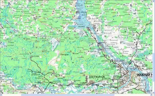
Rice. 1 Image of a 1: 500,000 scale map on the monitor screen
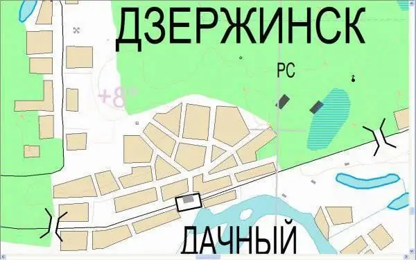
Rice. 2 Image of a fragment of the same map at a scale of 1: 50,000
In other words, in order to obtain detailed visual information about the area of the upcoming operation, the state of the terrain and local items, the commanders (commanders) and their staffs are forced to simultaneously operate several topographic areas of various scales. This significantly complicates the assessment of the terrain during preparation, and especially during the conduct of an operation (battle). But we are getting ahead of ourselves. Let's go back to our "virtual" brigade.
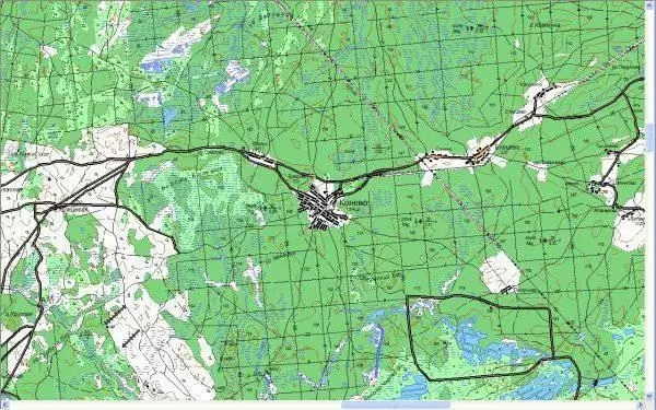
Rice. 3 Fragment of a 1: 100,000 scale map - the main map used by the brigade commander and headquarters.
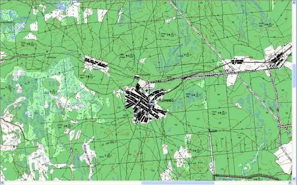
Rice. 4 Fragment of a map with a scale of 1: 50,000 - the main map used by battalion (division) commanders
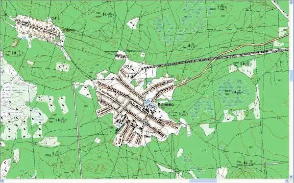
Rice. 5 Fragment of a 1: 25,000 scale map - the main map used by company and platoon commanders
At the moment (receiving a preliminary order), the commander, chief of staff and chief of the brigade's topographic service are forced to attend to the selection and "gluing" of not one, but several electronic areas of upcoming actions of various scales (Fig. 3-5).
That is, instead of using a "single" topographic base with a "through" image of terrain objects (in accordance with the selected visualization scale), the officers of our brigade are forced to use THREE different topographic areas of THREE different scales. Differing in the degree of detail, classifiers of the displayed topographic objects, and (which is important!) The year of publication of the original, i.e. published by typographic method, topographic base sheets.
For example. in the above fragments of sheets (files) of electronic topographic maps, the dates of shooting of the initial topographic material are as follows: for a map of scale 1: 100,000 - 01.06.2006. The map of scale 1: 50,000 - 01.01.1996. As the saying goes, "feel the difference." In some sheets (files) of electronic topographic maps used in the military, one can find such "rare" years of publication as 1992 and even 1986.
But that's not the point. Unfortunately, the vast territory of the Russian Federation has not yet been "digitized" on a scale of not only 1: 50,000, but even on a scale of 1: 100,000. But the normative accuracy of drawing topographic signs (objects) in each map is rigidly tied to its scale … That is, the larger the map scale, the more accurate the drawing of objects.
In practice, this means that only a 1: 50,000 scale map meets the coordinate determination accuracy criterion established for preparing data for artillery firing. Not a single sane artilleryman will determine the coordinates of firing positions and targets on a "hundred" map, even enlarged to a scale of 1: 50,000 - in order to avoid firing at his troops. And electronic "fifties" in the European part of Russia are currently "covered" in our country, at best, combined-arms training grounds and the Moscow region. Well, also the territory of the Chechen Republic and the surrounding areas. Also, a kind of "polygon". How are we going to shoot throughout the rest of the country?
Suppose, nevertheless, that all the sheets (files) of the required nomenclature and the required scales are at the disposal of the head of the brigade's top-service department. And this officer is able to create the appropriate areas from them in a short time. How will he pass them on to the performers? There are no questions with the brigade headquarters.
And the divisions? From the command post of the brigade to the most distant KNP of the battalion (division) in the area where the brigade is concentrated, it can be 25 and 30 kilometers. The size of a region file (*.map) with a scale of 50,000, consisting of only 8 sheets, ranges from 10 to 16 megabytes.
At the same time, as shown by field tests, the capabilities of the high-bandwidth microwave radio stations used in the Sozvezdiye-M complex are limited in range to three kilometers. Moreover, in an open area. The digital VHF radio stations available in the complex have a bandwidth of 1, 2 - 1, 6 kilobits / second. That is, it is very problematic to transfer files of this size over radio channels. Chasing liaison officers with flash drives to the brigade's command post? After all, the possibility of laying a field cable from the command post of the brigade to each KNP of battalions (divisions) and individual companies does not always exist.
Will it not turn out that the battalion commander will receive an electronic topographic basis of the battle area after its end?
2. Obtaining a combat mission
The commander of our "virtual brigade" can obtain a combat mission for the transition to defense in various ways:
the firm commanding voice of a senior boss (by phone or in person);
a package of textual documents (about 50 A4 pages in total), transmitted by telegraph, e-mail, or brought to the brigade by a feldeger-postal service (liaison officer);
in a graphical form (paper map, tracing paper, or an electronic map layer).
The latter method is the most preferable, since it allows the commander and the staff to begin work on clarifying the task immediately after receiving it without preliminary “decoding” and displaying the verbal constructions of textual documents on the map. The commander simply overlays the received electronic situation on his (electronic) map and immediately sees on the screen what the brigade should do.
How are things going with the transfer of the electronic graphical environment between the operational (army) and tactical (brigade) control levels?
Not yet.
The Directorate of the 20th Army, to which the 5th Omsb Brigade is subordinate, is armed with the Akatsiya complex produced by the Moscow concern Sistemprom. This complex allows you to work out the decision of the army commander (operational command) on an electronic map. Accordingly, the combat mission of the subordinate brigade can also be formalized in the form of a graphical environment file. It is undoubtedly possible to transfer to the brigade the layer of the electronic map, which was worked out at the army headquarters, containing a graphic image of its combat mission, through the available communication channels.
There is only one small "but". The Akatsiya complex uses the Rokada graphic editor developed by the Sistemprom concern to display the graphical environment. Naturally, the furnishings will be done in it.
And in the brigade, which has the ESU TZ complex, a completely different editor of the graphic environment is used, which was created in the Sozvezdie concern. It is impossible to open the file made at the army headquarters with the help of this editor, and, therefore, to see the brigade's combat mission directly on the electronic map of the brigade commander is impossible.
Two different programs, you know? Which differ even in the PRINCIPLES of creating and displaying a graphic environment.
What to do?
If the brigade has a terminal loaded with the Rokada software from the Akatsiya complex, the officers-operators will be forced to manually transfer the situation from the screen of this terminal to the screen of the terminal of their own system. But so far there is no such computer with the "Rokada" installed on it in the brigade.
Option: again, manually display on the screen what is written in the textual combat order (combat order, preliminary combat order) received from the army headquarters.
There is no other way yet.
3. Assessment of the situation
After clarifying the combat mission at the brigade headquarters, work begins to assess the situation. During the assessment, the commander draws conclusions, which, in fact, are elements of the design of the battle. In order for the assessment to be carried out quickly and at the same time with high quality, the work is distributed between the officers of management and headquarters, who work in parallel - i.e. the assessment of the enemy is made by the chief of reconnaissance, his troops - by the chief of the operational department, the assessment of the state of the terrain - by the chief of the engineering service, etc. For each item of the assessment, they draw conclusions and report them to the commander at the appointed time.
Stop. Established by whom? How do the officials know when the commander will hear them? And how much time is allotted for each presentation?
To do this, immediately after receiving a combat mission, the chief of staff (or, at his instruction, the chief of the operational department) makes a small but very important document - timing. In which it is determined who, what, when and in what sequence reports to the commander, how much time is allocated for making a decision, how much time is spent on planning a battle, when combat orders should be given to the troops, etc. All work on preparing the battle is organized in accordance with this calculation. Based on the calculation of the time, the work schedule of the brigade management, the schedule for preparing the brigade for battle and the personal work plan of the commander in the course of this training are drawn up (specified). All these documents should be coordinated in terms of time and activities. High-quality processing of these documents is the key to the coherence of the management.
At the same time, the order of work of the brigade management in preparing it for the main tactical actions is determined by charters and instructions, and, therefore, is known in advance. And it should be amenable to algorithmicization!
It would seem that this is the scope for automating control processes!
However, the software package "Constellation-M" does not provide for the automation of work on the creation, specification and communication of these important organizational documents to officials.
There are no such programs. Unfortunately.
Take a pencil, comrade boss, and by hand, by hand! In the best case, the above documents will be executed using software such as "Office" or "Open Office". In short, the American company "Microsoft" in this regard has so far done a little more for the automation of the Armed Forces of the Russian Federation than the Russian concern "Sozvezdiye".
4. Concept
In accordance with the principles of organizing work on the launcher, the commander of our virtual brigade can choose several "styles of work" when defining an idea and working out a decision. However, the main, and most often used, is the following.
The commander, based on the clarification of the task, the assessment of the situation and the preliminary calculations carried out by the headquarters, single-handedly determines the plan and works on the map, plotting the following points on it (for example, as in our case, during the transition to defense):
1. Direction of concentration of main efforts (NOCS).
2. Areas (sections) of the terrain on which the stability of the defense depends.
3. Outline of the forward position, leading edge, trenches and the position of the second and third positions
4. Outline of cut-off positions.
5. Lines and directions of counterattacks, etc.
In short, everything that is called "redness" in staff jargon constitutes the combined-arms basis of the plan. In fact, it is a "draft" of the idea.
Based on the standards for the development of an idea in the management of the brigade, no more than 20-25 minutes should be spent directly on the work of mapping these points.
At the same time, the BEFORE the commander brings these data to the top officials (his deputies and chiefs of combat arms and services), the faster, more consistently and better their proposals on the specific use of subordinate units of the combat arms and special forces, as well as support units will be worked out.
At the same time, it is IMPORTANT that NRViS would receive this data at the same time! Once they have received the “draft concept,” they can begin work on preparing their proposals.
Without automation tools, the process of defining the concept fell apart into sequential operations, since it was physically impossible to make ten cripples at the same time. And this greatly slowed down the work.
Example for clarification:
In order to place an artillery grouping on the ground (i.e.the chief of artillery to prepare the appropriate proposals for the commander), it is necessary to know exactly the NSOU. The tracing paper of the combined arms unit of the plan to the chief of artillery.
Further. Without knowing WHERE the main MFA grouping will be deployed, it is impossible to determine the position of air defense weapons. The tracing paper of the combined arms unit of the plan + tracing paper from the map of the chief of artillery - to the chief of the air defense.
Without knowing the positions of artillery and air defense, it is impossible to determine the routes for the delivery of missiles and ammunition to them. The tracing paper of the combined arms unit of the plan + tracing paper from the card of the chief of artillery + tracing paper from the map of the chief of air defense - to the deputy for armaments.
Thus, until the commander "draws red", and the chiefs one after another (ie sequentially transmitting graphic information about their proposals to each other) draw up them on the commander's card, the plan will not be displayed in the volume necessary for further work. This means that the headquarters will not be able to prepare preliminary combat orders for the units.
Conclusion: in the course of work on defining the concept with a manual method of control, there are three "bottlenecks":
displaying the combined arms unit of the concept on the map and transferring this graphic information to the deputy commanders and chiefs of the combat arms and services;
mutual informing of deputies and chiefs of combat arms and services about the graphic part of each other's proposals;
transmission of the agreed and approved by the commander graphic information about the proposals of the deputies and NRViS, as well as displaying it on the commander's working card.
In the case of organizing the work of a command and control system using an automated control system, the problem of a quick (rough) display of a combined-arms unit of an idea, in our opinion, should be solved by using an interactive board, on which the commander PERSONALLY puts the elements of the plan with an electronic felt-tip pen. Even if the concept does not look beautiful at the same time. So far, this is only a "draft".
The problem of the exchange and mutual coordination of graphic information between the commander and the officials involved in work at this stage should be solved as follows: SIMULTANEOUSLY displayed on all computers of the specified officials.
Those. the principle of multi-user access to the furnishings file (s) must be implemented. Of course, with the appropriate differentiation of user rights in which everyone has the right to see all the layers, but he can apply the environment only in the layers allocated to him for work, without the ability to change the situation in the “neighbor” layer. The commander, of course, should have the right to make changes in any layer.
It should look like this (Fig. 6):
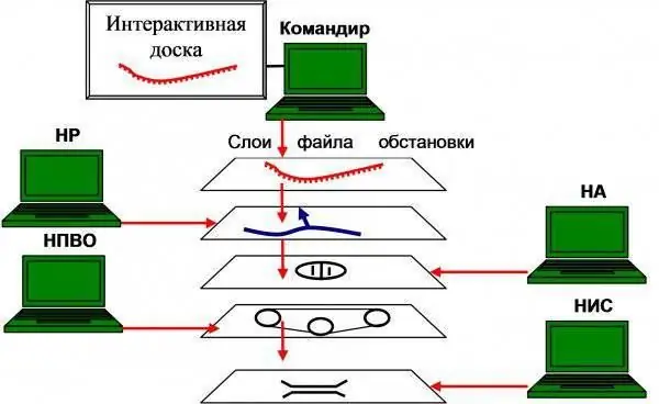
Rice. 6. Organization of multi-user access to the electronic map file
That is, in the presence of an automation complex, after the personal work of the commander using an interactive whiteboard and saving the one drawn by him personally in a file to which multi-user access is implemented, the DRAFT of the concept (its combined arms component) should be automatically and at the same time communicated to the subordinates involved in this work. stage. Moreover, in the most "easily digestible" - i.e. graphically. At the same time, time is not wasted not only on tracing paper, but also on the "beautiful" display of the combined-arms part of the plan by operators using a graphical editor. They will be able to "bring beauty" later - in parallel with the work of the commander with the NRViS on the definition of the plan, in terms of the types of troops and services and fire damage.
As a result, the commander, after personal work on the map, sees on the screen how the chiefs of the combat arms and services put their proposals on the "draft", and hears their textual part by videoconference. Deputy commanders and chiefs of combat arms and services simultaneously receive a "draft" of the plan, and also see all the details of the situation at their workplaces as they are drawn by "neighbors". At the same time, operators working directly with the commander, using a graphical editor, turn his "scribbles" into readable "eyelashes" and "arrows". The commander approves the NRW and C proposals as they are considered in accordance with the timing.
Everything. The idea is defined. You can report to your senior boss.
But this is the ideal.
What is the real situation?
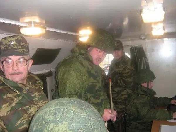
Rice. 7. Commander of the 5th Motorized Rifle Brigade during a brigade research command and control squad using ESU TZ "Sozvezdiye". In the hands of a control device - a wooden pointer
The developers of the ESU TK naively believed that the modern brigade commander would personally "use" the program of the graphic editor. I dare to assure them that for many reasons, he will not do this. Not now, not in the foreseeable future.
Consequently, the combined arms part of the concept will be applied to an electronic map by operators using a graphical editor. Naturally, at the direction of the commander. Wooden pointer. Since, an interactive whiteboard and the corresponding software, for the maximum simplification and acceleration of the commander's personal work on the electronic map in the ESU TK is simply not provided.
The principle of multi-user access to the file of the brigade commander's card is also not implemented in the ESU TK software. That forces the commander and officials of the brigade control to exchange e-mails with the attachment of their settings (in fact, the same tracing papers) as they are created. That is, in fact, the same sequential algorithm of work has been implemented, only with the replacement of cripples with electronic files. That artificially slows down the work of the brigade management.
There is also no such type of communication as video conferencing. Even between the officials of the brigade management.
If we add to the above the fact that the capabilities of the graphic editor used in the system do not allow to fully display all tactical signs provided for by the charters and manuals, and the officers operating the complex are deprived of the opportunity to create the icons missing in the classifier on their own, then the question of the quality of displaying the commander's plan on the electronic the map remains open.
Besides. To display the decision of the brigade commander on an electronic map, due to the imperfection of the graphic editor, it will take two to three times more time than when the same decision is drawn up "manually" on a conventional paper topographic base.
So, for example, the combination of five tactical signs depicted in Figure 8, denoting in general a motorized rifle battalion in defense, (without reference to the terrain) takes 1 minute and 10 seconds. The signs were applied by a trained operator - teacher 732 of the Center for Combat Use of ACCS of the Ground Forces.
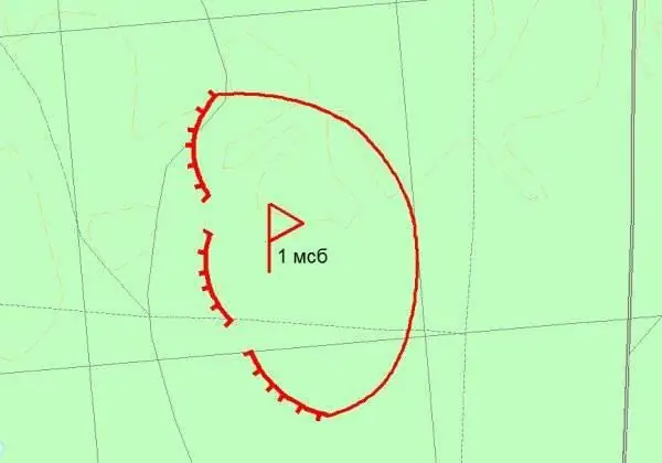
Rice. 8. Motorized rifle battalion on the defensive.
The combination of three tactical signs, shown in Figure 9, denoting the combined command post of a motorized rifle brigade and an anti-aircraft battalion in the area (also without specific reference to the terrain) takes 1 minute 20 seconds.
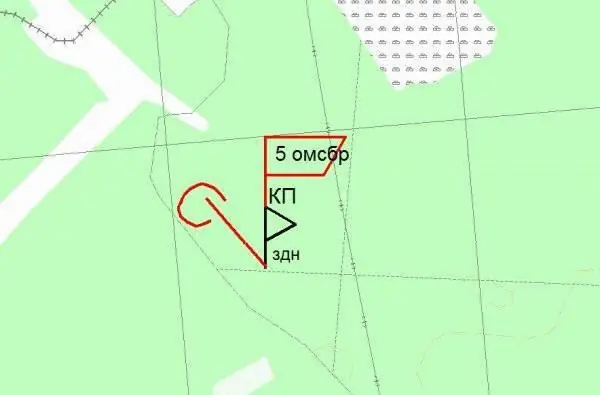
Rice. 9. Combined command post of a motorized rifle brigade and an anti-aircraft battalion in the area.
Application of a tactical sign indicating a tank unit leading an offensive (Fig. 10) - 37 seconds.
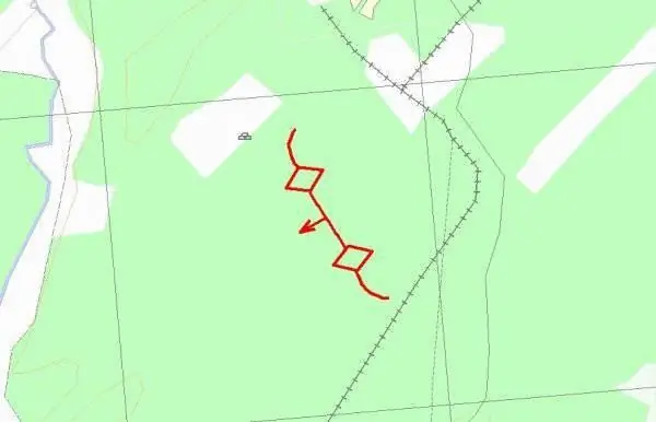
Rice. 10. Tank unit leading the offensive.
At the same time, the fully worked out graphic solution of the brigade commander in defense can number from 1500 to 2500 tactical signs (objects). If we assume that an average of 30 seconds will be spent on one sign (object), then the minimum total time for applying a solution to an electronic map will take 12.5 hours (excluding the time of binding the signs to the terrain). "It will be too much, however"!
The imperfection of the algorithms used and the TK used in the ESU complex is also noted by the Chief of Staff of the 20th Army of the Western Military District, Hero of Russia, Colonel M. Yu. Teplinsky, who supervised the preparation and conduct of the research command and control department with the 5th motorized brigade in Alabino:
“During the exercise, we set the task not to figure out the expediency of the decisions made, not to apply the situation in full, but to CHECK THE PASSAGE OF INFORMATION. Precisely because knowing the capabilities of the graphic editor and the classifier of tactical signs, to talk about plotting the situation in the "on-line" mode is to doom yourself to the absence of any result.
In order to inflict a motorized rifle squad - these are six elementary signs: a combat vehicle, a position, directly sign to make "1 MSO", and reveal the enemy in front of him, that is, a blue dash and sign that this is a motorized infantry platoon - six signs - it is necessary make about thirty-two mouse clicks. We win in terms of information transfer time, but we lose in terms of processing time.
That's why. Before the exercise, templates were made, in accordance with which the work of the brigade management was carried out. Templating was: provisions, decisions, actions. And in the course of the exercise itself, the templates were mapped, stretched, transferred, corrected, etc."


